

NOAA has reported the recent rainfall event as historic. It developed ahead of a slow moving cold front on Tuesday evening, 29 April 2014 over portions of coastal Alabama and the western Florida Panhandle. The cold front was associated with a very powerful low pressure system in the Plains. The widespread flooding produced sinkholes (some very large and deep), cut roads in half and necessitated human water rescues (one confirmed fatality). Parts of I-10 were closed. The Fish River at Silver Hill (Baldwin County Alabama) peaked at a record high level of 23.18 feet (previous historical record was 22.78 feet on 20 July 1997). Many folks throughout the area have compared this event to the extreme flooding impacts caused by Hurricane Danny (1997).
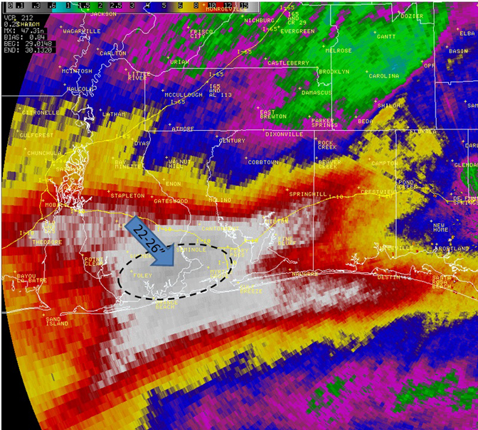
The rainfall totals below were contributed to by two predominant rounds of storms, the first occurred Monday night (28 April) and into the early morning hours when significant flash flooding occurred over coastal Alabama and the western Florida Panhandle. Some 3-8” occurred in association with the first event ending 7 AM CDT Tue., 30 April. The second and more significant event occurred during the evening hours of 29 April over Mobile and Baldwin counties of Alabama and the western most three counties of the NW FL Panhandle. In the latter, some 10-15” fell in a very short time period (estimated 9 hours preliminarily) and caused disastrous flooding throughout southern Baldwin County of Alabama and Escambia, Santa Rosa and Okaloosa counties of the western Florida Panhandle.

Also of note, the official NWS reporting sites at Mobile Regional Airport (MOB) and Pensacola Regional Airport (PNS) received some record rainfall amounts yesterday. MOB saw 11.24″ during the calendar day. This is their 3rd greatest calendar day total on record. Data here goes back to 1871. PNS saw at least 11.13″ which is for now recorded as their official amount. Data were lost due to power outage between 10-11 PM CDT, so amounts would have been higher. As it stands without the extra rainfall, this is their 4th greatest calendar day total on record. PNS rainfall data goes back to 1879. Of interest in the PNS total is the 5.68″ that fell in 1 hour between 02Z-03Z. A quick peek of the NOAA HDSC Precipitation Frequency map shows this to be a 1 in 200 year to 1 in 500 year 1 hourly amount.

The 24 hour amount is about a 1 in 25 year event. The Mobile 24 hour total is likewise about a 1 in 25 year event.
Finally and although not shown, it is worth mentioning that leading into the event, rainfall totals for the past two weeks and 30 days prior to the occurrence of this event that rainfall totals were 200-600% of normal according to 30 year PRISM Data
Information courtesy NOAA. For more information and graphics, go to: http://www.srh.noaa.gov/mob/?n=flashflood_04292014