Local eco guide describes access points, currents and landscape of local waterways in colorful detail
Earth Day was coming up and I wanted to scout a potential trip in lower Washington County. With that in mind I gave Lori from Walton Outdoors a call because as we all know she is game for new things. Unfortunately she had an interview that day and could not accompany us. Still working on the WWLD premise (What Would Lori Do) we decided to press on. It would turn out that we were doing exactly what Lori did do just on a different platform.
My mission was to access Mill Lake and the attached spring runs with paddle power only. Out came the maps and after an enjoyable half day of RBA (Recon By Automobile), we felt we had a plan. Due to swift currents we had to have a car shuffle but wanted to put our eyes on the put in and take out points. Our put in would be Shell Ferry Landing on Holmes Creek at the end of Potters Spring Road and our takeout would be Cedar Tree Landing at the end of Cedar Tree Landing Road. Go figure. Using the measuring tool on Google Earth I got approximate distances to waypoints along the way and an overall distance. Allowing for exploring in Spring Run we had a 9-10 mile trip planned. A good portion was going with the current in Holmes Creek and Boynton Cutoff on The Choctawhatchee (CR). We did not expect nor find much current in the Spring Run.

We arranged for a friend who lives in the area to work with us on the car shuffle. Shell Ferry Landing is county owned and probably safe to leave a car at, but having the transport help meant we could leave our vehicle at the busier Cedar Tree Landing. That statement is no reflection on the nearby residents as everyone we met was very nice and you could probably have left a wallet on your hood and come back and found it right where you left it. We launched around 11:30 and the adventure began.
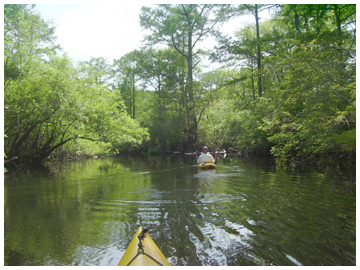
Holmes Creek current was almost nonexistent and we were immediately treated to the vibrant greens of the new growth on the cypress, tupelo, and hickories. A gator was spotted but submerged well before we got close. Bird life was laying low due to our late start. As we approached the cutoff the brown sediment waters of the Choctawhatchee were mixing vigorously with the greener waters of Holmes Creek. Well before we reached the cutoff we started moving against the current as the CR actually seemed to be flowing up Holmes Creek. The eddies and strong currents of the CR made for an exciting transition. The current on this cutoff was brisk as it is not as wide as some sections of the river. CR splits not too far upstream and comes back together 2 or 3 miles down. This forms an island known as Black Hammock. We came to a T intersection fairly quickly that resembled the satellite imagery we used to plan the trip. After a quick conversation with a fisherman we realized we had made a wrong turn. Back to the cutoff and a rapid run to the actual Spring Run. It is only 1.75 miles on Boynton Cutoff, 3.35 overall but it passes quickly with the current.

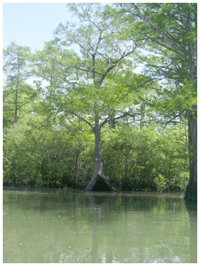
Spring Run was the next intersection. A short paddle brought us to another intersection. This was a Thursday and except for one waverunner leaving the run (sounded like an airboat) and a quiet bass boat 100 yards or so astern it was relatively quiet. I have heard this place can be somewhat of a zoo on weekends during the warmer months. We took the north fork up to Mill Lake and heard a lot of birdlife but saw only some herons, turkey buzzards and one osprey. This necked down to a narrow run that was so clear we expected to find a spring but did not. Mullet were ghosting by and what we think was a large (3’-4’) carp startled us somewhat. The views were absolutely primordial. The shapes that the cypress knees and bases of the other trees take approach abstract art. After coming to a point where the channel disappeared we returned to the intersection and made our way up the easterly fork.
It soon became apparent we were approaching the spring. Scattered cans started appearing on the bottom indicating this was a recreational area utilized by a wide variety of people. The spring was only a third of a mile or so from the second intersection and was nice. It has an area of clay deposits which make the water a bit cloudy but clear enough to tell that our main conservationists drink Nattie Lite. There were 5 or 6 guys pulled up in a bowrider ski boat who joined us in an impromptu cleanup effort. We learned they had put in at Black Creek. The presence of the clay makes me wonder if that is why it is called Potters Spring.
It was time to time to head back to the CR. The current remained swift until the two channels came together and the river doubled in width. Adding to this was the fact that the river ran fairly straight in a south-southwest direction and that was exactly where our afternoon convection wind was coming from. The wind balanced the current almost exactly so this last leg was a little tedious. Take out was smooth and there ended the excursion.
So to summarize the trip: The trip can take 4-6 hours depending on how much exploring you do in Spring Run. Allow for 1-1.5 hours for the final leg depending on the wind. I would put the paddling somewhere between intermediate to advanced due to swift currents and possible headwinds on the lower section. Check the river stage before you go. The stretch you will be paddling is remote so file your float plan. Bring emergency supplies including signaling devices in the event of a worst case scenario. Wear your life jacket because if you need it, it needs to be on you. Paddle safe.
Karl Renalt is the owner and guide for Into The Wild Eco Adventures. To find out more, go to http://www.itwecodiversions.com/
