
Paddling, hiking, camping, horseback riding, fishing, and hunting within 41,363 acres
Note: Some of the photos in this story were taken before Hurricane Michael in 2018 which caused extensive tree damage.
Imagine paddling along a creek lined with fern draped limestone rocks, dipping in a cool spring, hiking along a trail bluff dotted with wild azaleas, mountain laurel, and the sweet scent of Florida anise. Or, how about camping under the stars with your friends, family, or even your horse?
Econfina Creek Water Management Area boast the most extraordinary and diverse recreation opportunities in northwest Florida. Managed by Northwest Florida Water Management and Florida Fish and Wildlife Conservation Commission, the recreation area offers paddling, horseback riding, swimming, fishing, hunting, hiking, camping, and wildlife viewing all within 41,363 acres of unparalleled scenic beauty.
The majority of the recreation area lies just north of State Road 20 in Washington and Bay counties between SR77 and SR231. The landscape boasts a diverse habitat of xeric sandhill uplands with dozens of shallow, clear sand-bottomed lakes, and the popular spring fed Econfina creek.
Econfina Creek paddling
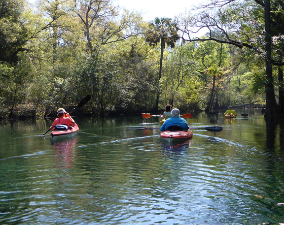
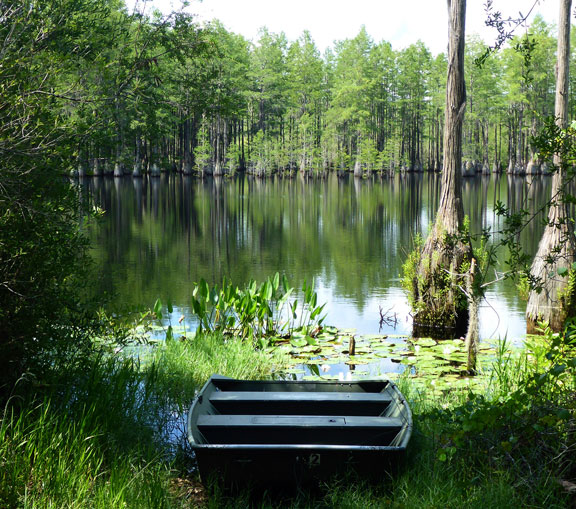
Econfina Creek boasts dozens of beautiful springs that await the paddling explorer. The spring fed creek is many a paddlers’ favorite journey in the Florida Panhandle.
The creek flows steep and narrow beneath forest canopies through Jackson, Washington and Bay counties. The steepest gradient of any designated canoe trail in Florida, it winds through narrow chutes and passes cascading waterfalls. As the creek approaches State Road 20, it slices into the ancient limestone of the Floridan Aquifer and gathers abundant flows from numerous springs.
Pack a lunch and bring your snorkel, for you are about the enjoy the paddle of a lifetime as you explore the creek and its many crystal clear springs along the popular creek. Blooming wildflowers scatter the banks with vibrant color during your journey in the spring and summer months.
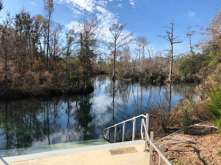
There are a few access options available on the creek. The launches are located at Scotts Road (upper creek) currently this portion has heavy tree blockages, Walsingham Bridge (middle creek) and Highway 20 (lower creek). The upper portion of the creek is especially strenuous and should only be attempted by experienced paddlers. Water level conditions are a factor and you may encounter many portages in the upper sections above the Econfina Creek Canoe Livery.
Access to the creek is located in a parking area/launch on the east side of the creek on SR20. Note that SR 388 is the take out.
Econfina Creek spring recreation parks
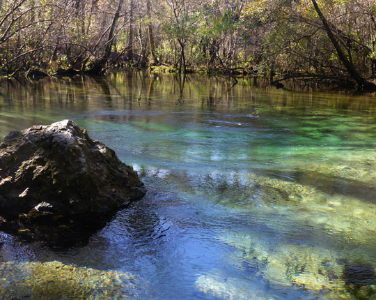
For those interested in dipping into a cool 68 degree crystal clear spring without a paddle, Econfina Creek offers a few options. These recreation area parks can be accessed by vehicle, and offer a perfect family-oriented experience.
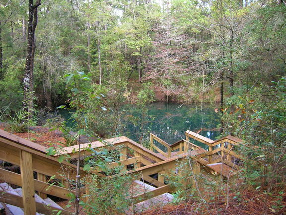
PITT AND SYLVAN SPRINGS: Pitt Spring and Sylvan Spring is a popular recreation area. The water from Pitt Spring’s 11-foot-deep spring vent emerges from beneath a submerged limestone ledge into a 40-foot diameter pool and then flows through a 50-foot run to the creek. The 10-acre recreation area includes an extensive trail and boardwalk system. One trail and boardwalk system leads from Pitt Spring to the Sylvan Spring area, and includes an overlook and a tubing put-in dock. A tubing take-out dock has been constructed at the confluence of Pitt Spring run and Econfina Creek. Swimmers can access the water by stairway. Covered picnic pavilions and a composting restroom are available. Click here to learn more.
Latitude/Longitude: 30.432718, -85.546503
BLUE SPRING: Gin clear water emits from the spring offering cool swimming in a secluded area on Econfina creek. Easy access with steps and a shallow water area make it perfect for anyone to cool off on a hot summer day.
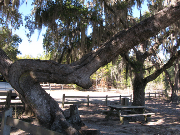
The park boasts large oak trees, picnic tables, pavilion, portable restroom, fire rings, and grills. Parking is limited unless you make camping reservations through Northwest Florida Water Management here.
Blue Spring is located off of SR20 on North Blue Springs Road, Youngstown.
Latitude/Longitude: 30.453238, -85.529542
WILLIFORD SPRING: Recreational area offers spring entry steps, patio terrace, spring view deck, canoe dock, boardwalks, composting toilets, picnic pavilions, parking area, as well as interpretative boardwalk and native landscaping throughout the site.
Latitude/Longitude: 30.439702, -85.547447
Camping
A variety of camping areas are offered within the recreation area. No alcoholic beverages or ATVs allowed. Motorized vehicles permitted in designated areas only.
Campsites are free and reservations can be made through Camplife.com
BLUE SPRING: Gin clear water emits from Blue Spring offering cool swimming in a secluded area on the creek. Easy access with steps and the shallow water make it perfect for families to cool off in a cove like area.
The campsite area has large oak trees, picnic tables, pavilions, RV spots, fire rings, grills, and portable restroom. The area can accommodate up to 25 people. Latitude/Longitude: 30.453238, -85.529542
DEVIL’S HOLE: Devil’s Hole is a 40-foot swallet sinkhole that connects to the Floridan Aquifer. Preserving this area is essential for protecting groundwater resources. The Florida National Scenic Trail and Econfina Creek pass through the area just to the west of Devil’s Hole. The Devil’s Hole Recreation Area offers a day use area with picnic tables and a portable toilet. A single campsite equipped with picnic table, fire ring, and a grill is available by reservation. Day use is allowed from dawn to dusk in the designated Day Use area. Latitude/Longitude: 30.493152, -85.519295
LONGLEAF: A primitive campsite located on Econfina Creek and offers a picnic table and a fire ring. The nearest portable toilet is located at the Walsingham Bridge park. Latitude/Longitude: 30.489186, -85.521505
RATTLESNAKE LAKE NORTH: Rattlesnake Lake North is known as “the side with the boat ramp” where families can enjoy swimming, camping, kayaking, and canoeing. It offers a picnic pavilion, pedestal grill, fire ring, and portable toilet. This site can hold a maximum of 25 people. This Day Use area and boat ramp are open as a “Day Use Only” site daily from dawn to dusk from Thanksgiving Day through the first Wednesday in February. Latitude/Longitude: 30.4613, -85.564013
RATTLESNAKE LAKE SOUTH: Rattlesnake Lake South is known as “the beach side” because of its white sand beach where families can enjoy swimming, camping, kayaking, and canoeing. It offers a picnic pavilion, pedestal grill, fire ring, and portable toilet. This site can hold a maximum of 25 people.
Latitude/Longitude: 30.454713, -85.564646
SEASHELL: Seashell is located on Econfina Creek directly south of Devil’s Hole Spring. This campsite offers a picnic table and a fire ring. The nearest portable toilet is located at the Walsingham Bridge campsite. Latitude/Longitude: 30.489999, -85.521902
This location was named “Seashell” for the soil layer of limestone along the edge of the creek that has visible prehistoric shell deposits. Removing these shells is prohibited.
TOM JOHNS LANDING: Tom Johns is a beautiful retreat and millennia-old hunting base camp, judging by stone point fragments recovered nearby. The District has replanted natural vegetation and protected aquatic habitat with designated boat landings and rail fencing. Tom John’s boat landing is located at the north end of Porter Lake and offers good fishing, a pavilion, picnic tables, fire rings, pedestal grills and a portable toilet. Four campsites are available by reservation; two are “tent only” camping, and two can be used for tents, travel trailers, and RV’s. Day Use is permitted from dawn to dusk in the designted Day Use area. Latitude/Longitude: 30.508054, -85.541514
WALSINGHAM: Walsingham Camp Site is a primitive campsite that is on the west side of the creek, north of the Walsingham Bridge. The Bridge connects the campsite to Walsingham Park. Latitude/Longitude: 30.480948,-85.523179
WALSINGHAM PARK: Walsingham Park has a Water Management District canoe/small boat launch with primitive camping and picnic area, ideal for experiencing mid-creek flora and fauna. Walsingham Park offers a picnic pavilion, pedestal grill, fire ring, and tent camping. A portable toilet is located at this site for use by campers at Seashell, Longleaf, and Devil’s Hole, as well as both Walsingham sites.
Latitude/Longitude: 30.482631, -85.523694
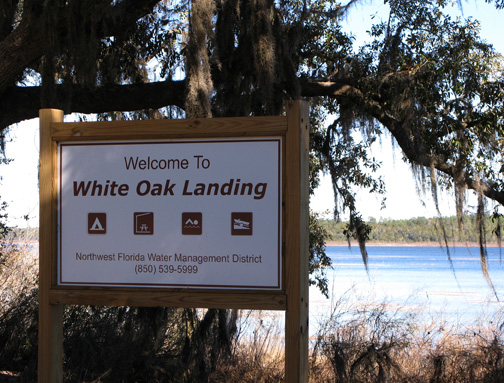
WHITE OAK BOAT LANDING: White Oak Boat Landing is a centuries-old campsite, as evidenced by recovered pottery pieces. The District restored the shoreline and aquatic habitat by replanting eroded areas and constructing a designated boat ramp. White Oak Boat Landing is located on the south end of Porter Lake and offers a pavilion, picnic tables, pedestal grills, fire rings, portable toilet and three camping sites. Day Use is permitted from dawn to dusk in the designated Day Use areas. Latitude/Longitude: 30.498597, -85.551331
WHITEWATER LAKE: Whitewater Lake is a campsite that will hold a maximum of 10 people. This is a great location for family camping and a rare steephead habitat is located nearby. This campsite has a screened pavilion, a picnic table, fire rings, pedestal grills, a dock, and portable toilet. Latitude/Longitude: 30.48288, -85.551256
Equestrian Trails
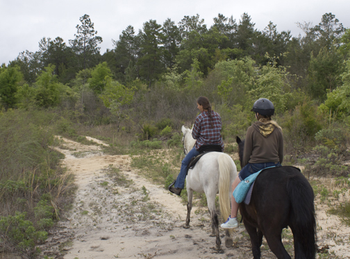
Head out to the miles and miles of equestrian trails along Econfina recreation area. At the end of the day you and your steed can camp out under the stars at the Pine Ridge Recreation area.
PINE RIDGE: The Pine Ridge Equestrian Trail was established by the Northwest Florida Water Management District, volunteers of the Southern Trail Riders Association, and other local saddle clubs in order to designate around 45 miles of trails in Econfina Water Management Area. Visitors can park at Pine Ridge Campground (off Greenhead Road) and ride along Rolling Pines Connector, across State Road 20 to Wolf Pond Equestrian Trail. This campground offers eight campsites, picnic tables, fire rings, pedestal grills, a portable toilet, and space for your horses and trailers. To protect water resources, equestrians must stay on designated trails or be subject to a fine. Day Use is allowed with specified parking outside the campsite areas. A reservation is required to camp.
SCOTT ROAD: Latitude/Longitude: 30.548985, -85.43584
SPARKLEBERRY TRAIL: Latitude/Longitude: 30.472765, -85.496099
WOLF POND TRAIL: Latitude/Longitude: 30.423032, -85.606381
Interested in finding a stable to rent a horse back ride or trail guide? Check out Sunshine Riding Stables.
Hiking
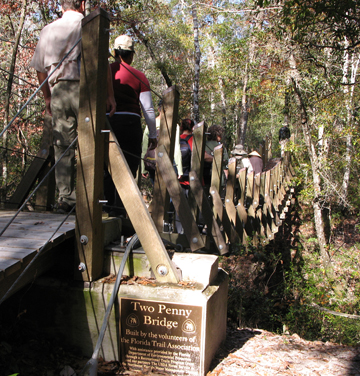
The Florida National Scenic Trail runs diagonally through the Econfina Creek Water Management Area. More than 27 miles of trail treks along the creek, and along sandhill uplands, wetlands, and scenic bluffs. A portion of the Trail which runs along the creek is approximately 18 miles.
Along the trail you will discover a waterfall, sinkholes, ponds, suspension bridges, and hike-in camping areas.
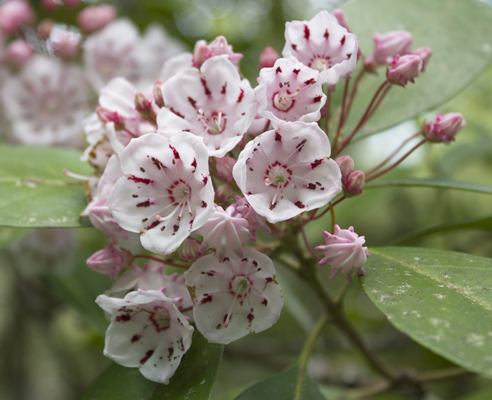
In the springtime, you can find mountain laurel and rhododendron blooming along with vibrant Florida anise. In the fall, a variety of hardwoods provide subtle color changes of red and orange hues along the shady creek portion of the trail.
There are three convenient accesses. Choose from Scott Road trail head off of U.S. Hwy. 231 just north of Fountain; SR 20 trailhead between SR 77 and U.S. Hwy 231 near Pitt Spring or Walsingham Bridge, accessible via Strickland Road off of SR 20 north of Pitt Spring. Trail Map
Hunting:
The 41,363-acre area runs 14 miles along the course of Econfina Creek and also encompasses mile after mile of xeric sandhill uplands with dozens of shallow, clear sand-bottomed lakes. These uplands recharge the springs that feed the creek. Most of the area was planted with commercial stands of non-native sand and slash pine, which are being harvested and restored to longleaf pine and wiregrass habitat. Along the creek hardwood forests and hammocks grow above fern-covered limestone bluffs and outcrops.
Click here for map of hunting areas. http://myfwc.com/hunting/wma-brochures/nw/econfina-creek/
Econfina Creek WMA – Fitzhugh Carter Tract
An independent parcel of Econfina Creek WMA named the Fitzhugh Carter Tract, lies just west of Highway 77, 5 miles north of Highway 20 in the Greenhead community. This 2,175-acre tract contains a wide variety of habitat types, including xeric sandhill uplands, portions of upper Pine Log Creek, various wetland habitats, and clear, sand-bottomed lakes. Non-native sand and slash pine plantations have been harvested, and the uplands are currently being restored to their original condition of longleaf pine and wiregrass.
While it is in part a wildlife management area, the Carter Tract is also a mitigation bank property, purchased by the Northwest Florida Water Management District (NWFWMD) to offset development impacts to other wetlands in the surrounding areas. The primary objective of the Carter Tract is the preservation and restoration of the wetlands and surrounding uplands on the property. Thus, recreational use is limited and more intensively managed on this wildlife management area than most others in the Northwest Region. While the Carter Tract is open to access on foot everyday during daylight hours, public vehicle access is limited to Friday through Monday (except during established hunting seasons) and is restricted to improved roads. Camping, swimming, horseback riding, use of bicycles and ATVs are all prohibited on the area.
In the 1960s and 1970s Carter Tract operated as a popular fishing ranch by its owner, Mr. Fitzhugh Carter. During drought conditions, some of the old cypress boats Mr. Carter built and rented to anglers can be seen exposed on pond banks throughout the area. The tract was later leased as a private hunting area. Knowing the rich history of recreational use and recognizing its potential for high quality recreational opportunities, NWFWMD entered into an agreement with the Florida Fish and Wildlife Conservation Commission to manage the property for limited recreational use and to conduct ongoing monitoring of fish and wildlife resources. Learn more about the Fitzhugh Carter Track here.
Note: Many of our photos were taken prior to Hurricane Michael which destroyed many trees within the recreation area.