
Explore the many facets of the Choctawhatchee River
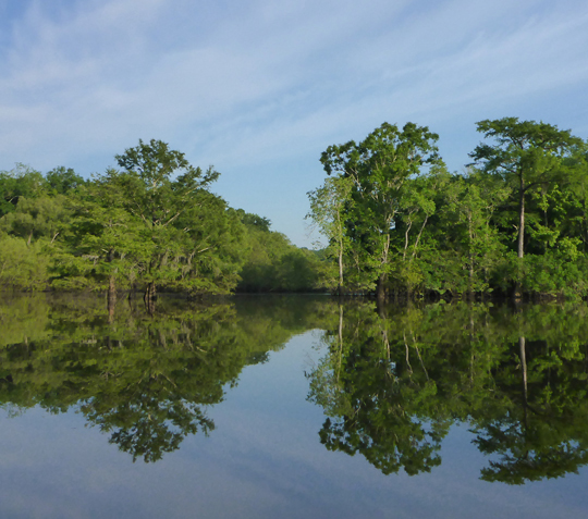 Originating in southern Alabama, meandering south through northwest Florida in Holmes, Walton, and Washington counties, is the ever-changing Choctawhatchee River. The river arises and flows close to 140 miles southward, to eventually empty into the Choctawhatchee Bay.
The Choctawhatchee is alluvial, characterized by a broad floodplain, prone to seasonal flooding, and heavy sediment load. Alluvial rivers are self-formed, meaning their channels are shaped by the magnitude and frequency of the floods experienced, and the ability of these floods to erode, deposit, and transport sediment. The sediment shifts and flooding ensure the river is ever changing. The river receives significant quantities of water source from the Floridan aquifer system, and has both black water and spring-fed tributaries.
Native Americans facilitated the waterway since the1700s for hunting, fishing, and trading. Their goods were traded as far away as Pensacola via the waterways of the Choctawhatchee River, Bay, and Santa Rosa Sound. Through the later 1800s to the mid 1900s, the river was heavily used for commerce such as cypress logging, turpentine trading, and fishing. Cypress dead-head logging continues to this day.
Click here to continue.
Explore nature at St. Marks National Wildlife Refuge

Eighty-year-old refuge a step back into old Florida
Imagine…. 68,000 acres of pristine Florida shoreline preserved for wildlife habitat and outdoor recreation. Sounds to good to be true, then you should head over to St. Marks National Wildlife Refuge and step back time into the real Florida.
Celebrating its 80th anniversary this year, St. Marks NWR was established back in 1931 to provide wintering habitat for migratory birds. Located between the Ocholockonee and Aucilla Rivers along the Gulf coast of Northwest Florida, the refuge is home to abundant and rare wildlife that thrive within the coastal marshes, islands, tidal creeks, swamps and pristine upland forests.
The broad range of wildlife varies from month to month, for best viewing opportunities, click here.
The refuge has four geographical units:

St. Marks is home to the headquarters and new education center. A seven-mile scenic drive through fresh and brackish water will lead you to a historic lighthouse built in 1832, which is still in use. The Florida Trail runs through this section offering hiking and birding opportunities. Boat ramps, picnic tables and scenery make for an extraordinary nature experience.
St. Marks is the winter home for the endangered whooping cranes. For the past few years, Operation Migration has been escorting the cranes every winter from Wisconsin.
Explore the natural beauty of St. Vincent Island
Have you ever wanted to step back in time and explore the natural beauty of Florida? Pack yourself a lunch and head over to the undeveloped treasure chest that awaits you at the St. Vincent Island National Wildlife Refuge (NWR).
Located at the mouth of the Apalachicola River, in the Gulf of Mexico, St. Vincent Island NWR is a 12,300-acre barrier island. The island is 9 miles long and 4 miles wide. The triangular island is larger than most of the northern Gulf coast barrier islands and dissected by dune ridges, freshwater lakes and sloughs on the east end. The west ends supports dry upland pine forests.
The island is a haven for an abundance of wildlife including migratory birds, raptors, alligators, deer, and red wolves. It is rich with plant life that includes pines, hardwoods such as scrub and live oak, spiderwort, St. John’s wort, and gallberry, saw palmetto to name a few. The beach is a delight for shell seekers, as the tiny gems scattered along the south side of the island are a pocketful of keepers.
Accessed only by water, options to get there are paddling, boating or by shuttle boat located at the Indian Pass boat ramp. Call (850) 229-1065 for shuttle information/reservation. ::MAP::
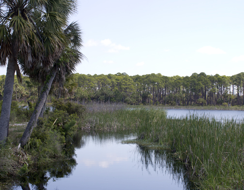
Explore the springs of Northwest Florida

Not only our most valuable water sources, spring fed waterways provide extraordinary adventure
Some of the most beautiful places to explore Northwest Florida are along our spring fed waterways. These creeks, streams and rivers provide incredible recreation and eco tourism along with the valuable drinking water our communities rely on.
Florida boasts more than 700 springs, with close to 40 in the Walton, Holmes, Washington and Bay counties. Blue Spring and Jackson spring in Holmes County feeds into the Choctawhatchee River and is Florida’s 12th largest spring with 122 million gallons per day discharge. Holmes Creek has more than a dozen springs and is the largest tributary into the Choctawhatchee River. The Gainer Springs Group on Econfina Creek (including springs locally known as McCormick and Emerald) is the most significant, measuring a first magnitude flow of 114 million gallons a day (mgd). Econfina creek feeds into Deer Point Lake which is the major source of water supply for Bay County.

What are springs?
Springs are portals where water in the earth’s aquifers, rises to the surface and escapes into our streams, lakes and coastal waters. There are two general types of springs in Florida, seeps (water-table springs) and karst springs (artesian springs). The springs in Northwest Florida are karst springs. Karst topography is a landscape created by groundwater dissolving into sedimentary rock such as limestone. This creates landforms such as shafts, tunnels, caves, and sinkholes. The Dougherty Karst Plain underlies our area.
What is a spring classification?
Springs are most often classified based upon the average discharge of water. Individual springs exhibit variable discharge depending upon rainfall, recharge and groundwater withdrawals within their recharge areas. One discharge measurement is enough to place a spring into one of the eight magnitude categories. However, springs have dynamic flows. A spring categorized as being a first-magnitude spring at one moment in time may not continue to remain in the same category. This can result in a spring being classified as a first magnitude spring at one point in time and a second magnitude at another.

What will I find exploring a spring and a spring fed waterway?
These beautiful waterways of Northwest Florida are abundant with fish and plant life.
Here is a list of the most common things you will find:
Fish:
Largemouth bass, spotted bass, bluegill, sunfish (shellcracker), redbreast sunfish, warmouth, black crappie, striped bass, catfish, alligator gar, bowfin.
Invertebrates:
Florida Apple snail, freshwater mussel, pond crayfish, six-spotted fishing spider, mayfly, diving beetle, giant waterbug, dragonfly, damselfly, mosquito, biting fly, butterfly.
Reptiles:
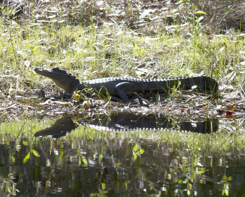
Florida green water snake, cottonmouth/water moccasin, Florida snapping turtle, American alligator, salamanders, newts, treefrogs.
 Mammals:
Gray squirrel, river otter, beaver, raccoon
Birds:
Wood duck, mottled duck, great blue heron, great white heron, green heron, ibis, swallow-tailed kite, bald eagle, hawk, owls, osprey, kingfisher, warbler, scarlet tanager.
Trees/Plants/Grasses:
Bald cypress, live oak, red maple, pawpaw, black titi, red titi, Cherokee bean, sweetbay, blackgum, juniper, red cedar, southern magnolia, laurel oak, tupelo, hickory, willow, wax myrtle, cabbage palm, saw palmetto blueberry, hydrangea, St. John’s wort, mountain laurel, water lily, pickerelweed, pitcher plant, broad leaved arrowhead, fern, moss
Where can I find a spring fed waterways to explore?
There are almost endless possibilities of places to explore in a kayak or a canoe. Here are four of the best places to launch or rent a kayak or canoe, or enjoy swimming in the cool water of a spring fed wateray.
Here is a Lat. Lon listing of springs in Walton, Holmes , Washington and Bay counties: springlocationlist
________________________________________________________
Econfina Creek in Washington and Bay County

Part of Florida’s Greenways and Trails, the Econfina Creek in Bay and Washington counties is many a paddlers’ favorite journey in the Florida Panhandle.
Pack a lunch and bring your snorkel, for you are about the enjoy the paddle of a lifetime as you explore the creek and its many crystal clear springs along the popular seven-mile trip down the creek. Cabbage palms drape over the water’s edge along with blooming wildflowers scattering the banks with color during your journey in the spring and summer months. Steep, fern-covered limestone walls prevail along the second half of the paddle, where the creek slices into the ancient limestone of the Floridan Aquifer.
The northern portions of the creek are difficult with many logjams and shallow water. Most paddlers opt to put in at the Econfina Livery as the livery offers the option of pick up and return at the take out at SR 388 bridge. They also have kayaks and canoes available for rent.

The Econfina Creek is largely preserved and managed by the Northwest Florida Water Management District, and part of the much larger 41,000 acre Econfina Creek Water Management Recreation Area. The Recreation Area offers camping, hiking along the Florida Scenic Trail, boating, fishing and equestrian trails along with campsites and recreational parks.
The District has identified 11 springs or spring groups comprised of 39 individual vents, most of them within a mile of State Road 20.
There are several places to launch a canoe or kayak:
• Scott’s Bridge – From US 231 four miles north of Fountain, take Scott’s Road west four miles to bridge. (This is the upper portion of the creek and for skilled paddlers only as there are many portages due to log jams)

• Walsingham Bridge – From SR 20 turn north on Strickland Road which becomes Porter Pond Road. There is a fence line on the right side of the road. Follow the fence line and make the two right turns where the fence turns. Take Washington Bridge Road to the bridge.
• Econfina Canoe Livery – One mile north of SR 20 on Strickland Road. Eight miles east of Hwy. 77, offers both canoes and kayaks for rent along with a shuttle back to your vehicle after your paddle. Call 850-722-9032 for more information, or go to: http://canoeeconfinacreek.net/
• SR 20 Bridge – (1 mile) limited parking.
• SR 388 Bridge – (6 miles)
________________________________________________________
Holmes Creek in Washington County

As part of Florida’s statewide system of Greenways and Trails, Holmes Creek flows through a variety of diverse habitats. The upper and lower portions pass high sandy banks while the majority of the tail is through low-lying swamplands.
Rich with flora and fauna, the creek is abundant with turtles and birds, including blue, green and white heron, ibis, warblers and woodpeckers.
Several sections of the creek are shallow and clear. Underwater plants seem alive with movement as they ripple under the water’s surface. Water lilies are in abundance, and on this mid-summer day, were just starting to bloom.
Bird and wasp nests dangled from the trees seemed almost as though suspended in air as you looked above towards the treetop’s canopies.

There are several crystal clear springs, including Cypress Springs, which flows at 89 million gallons per day and Becton Springs, which flows at 40 million gallons per day, that feed the creek. There is a smaller spring at the Brunson landing where you can pull in, take a short walk along a wooded trail and find the small spring approximately 35 ft. in diameter.
Bring your snorkeling gear, as a dive into Cypress Springs is one of the highlights of the paddle offering you the opportunity to get up close and personal with a beautiful spring boil.
The creek has many low-hanging branches and submerged tree trunks, which can present a small, but not difficult challenge. For the most part, the gentle curves and a slow current make Holmes Creek an easy paddle through beautiful hardwood swamps.

Launches:
A. Cotton Landing: 3 miles north of Vernon on CR 277. This managed by Northwest Water Management District with primitive camping allowed. There is a small pavilion with tables, a portable toilet, fire ring, and area for tents or trailers. It is down a 1 mile gravel road from County Hwy. 278.
One mile downstream, the Cypress Springs run is on the right, paddle a short distance upstream to a swim and snorkel in a Magnitude 2 spring. The land is privately owned, but allows boaters access as long as visitors keep the area clean.
B. Culpepper Landing: Travel north on CR 277 for 2 miles to a Washington County Boat Ramp. Put your boat in here and paddle upstream for less than a mile, and then up the Cypress Springs run. After playing in the cold, clear water, you can go back to the Culpepper Landing and take-out, or continue two miles downstream to the Vernon Boat Ramp, or chose the longer paddle to Hightower Springs Landing.
Map locations:
1. Canoe Livery service for Holmes Creek:
Holmes Creek Canoe Livery
Located at SR 79 just North of the Vernon bridge.
To find it, drive into the Vernon Park and boat landing
Kayaks and aluminum tandem canoes rentals
The livery provides shuttle service for $15 for those with their own boat.
850-210-7001 or go to: holmescreekcanoelivery.com
2. Brunson Landing: Turn left on CR 278 immediately before the bridge, travel two miles, and turn L on Dorch Circle, and again left on Bronson Landing Road. This is a more primitive landing than Fanning Branch or Hightower. No facilities were available.
3. Hightower Springs Landing: This is a take out option for your paddle. There is a small springs with a pond on the left side of the landing. Local people say they swim in the spring, but the banks were swampy and the edges mucky to wade out into the water. There are picnic tables, grills, and a portable restroom.
4. Take-out: Live Oak Landing
Directions to take-out: From Vernon travel south on SR 79 to junction of SR 284, turn right (west) and drive about 1.3 miles to Hancock Rd. Turn right on Hancock Rd. and go 1 mile to Live Oak Landing Rd. Turn left on Live Oak Landing Road and drive about 0.5 miles to public boat ramp
________________________________________________________
Morrison Springs in Walton County

Just south of Ponce De Leon, the 161-acre park is well known in the area, and popular with divers and nature enthusiasts across the south. Cypress trees abound around the spring with their crisp, bright green needles defining the landscape. The spring provides an aqua color inviting everyone in for a dip.
The highlight of the park is a 250-foot diameter spring pool that produces an estimated 48 million gallons of crystal clear water each day and has been recorded to produce up to 70 million gallons a day. Three cavities allow Morrison’s frigid waters to surface from the underground aquifer. The deepest of these cavities, at approximately 300 foot in depth, eventually terminates in an underground chamber of unknown dimensions. Morrison Springs is a favorite of divers.
575 linear ft. of boardwalks meander through the ancient cypress trees, and span into the springs to a diver’s launching area, with a 10×10 ft. 9,000 lb. floating concrete platform.

Restroom facilities, a pavilion with picnic area, wash stations, showers and handicap access are available at the park now, offering it the perfect family destination.
There are 72 parking spaces at the entrance to the park, which include 10 bus and 4 handicap spaces. There are 24 boat/trailer spaces located at the boat ramp.
The park was acquired by the state in 2004 and its management is now entrusted to Walton County for 99 years. The project is also part of the ‘DEP Springs Initiative;’ a comprehensive protection effort which provides funding for springs restoration throughout the state of Florida.

Directions:
Morrison Springs is located in the most southeastern part of Ponce deLeon just inside the Walton County line. From Freeport, take State Road 20 east to State Road 81 and go north past Red Bay to County Highway 181C. Turn right and continue 1.6 miles. Turn a right on Morrison Springs Road. This is a County park there are no fees. Open from 8 a.m. – sunset.
________________________________________________________
Ponce deLeon Springs State Park in Holmes County

Just outside the Walton County line is one of the coolest places to take a dip in a spring, Ponce de Leon Springs State Park. As the water stays a constant 68 degrees Fahrenheit year-round, both locals and visitors enjoy this nature-made swimming pool, which is a convergence of two underground water flows, producing 14 million gallons of water daily.
The main vent is centrally located in the pool at a depth of 16 feet and is about 9 feet in diameter. A second vent about 10 feet from the north bank is a circular chimney 6 to 8 feet in diameter with a depth of 16 feet. A few feet from the north bank near the spring-run is a third vent. The aquatic cave habitat has been greatly improved because of recent efforts to remove organic sediments and debris that had previously blocked the vents. The park’s aquatic cave is likely home to cave crayfish.
This beautiful spring is named for Juan Ponce de Leon, who led the first Spanish expedition to Florida in 1513 – as legend has it, in search of the “fountain of youth.”
The park has a long history as it has been facilitated as far back as the early 1900s, and at one time, offered a roller skating rink. The State acquired the springs in 1970.
The spring area boasts an open pool with easy access steps entering the water. The crystal clear water shows bream and bass swimming around below.
Visitors can take a leisurely walk along two self-guided nature trails through a lush, hardwood forest and learn about the local ecology and wildlife. The walk offers a closer look at Sandy Creek, where the springs empties into, and eventually leads to the Choctawhatchee River.
Local flora includes mountain laurel, magnolias, cypress, holly, cedar and oak trees. Snakes, fox, and lizards are a common sight in the area as well.
There are four pavilions offering grills and picnic tables. There are several more tables and grills scattered around the park offering the perfect place to hold a family picnic. Rangers also conduct seasonal guided walks, and anglers can enjoy fishing for catfish, largemouth bass, chain pickerel and panfish.
Hours of Operation
8 a.m. to sunset

Driving Directions:
Ponce de Leon Springs State Park Area is located one half mile south of U.S. 90 on C.R. 181A in Ponce de Leon, Fla.
Park Fees:
Admission Fee – $4.00 per vehicle.
Pedestrians, bicyclists, extra passengers, passengers in vehicles with holder of annual individual entrance permit – $2.00
Ponce de Leon Springs State Park
2860 Ponce de Leon Springs Road
Ponce de Leon, Florida 32455
Phone: 850-836-4281
———————————————————————————————————————————
Paddle, swim, fish or cave dive at Merritt’s Mill Pond in Marianna

Self guided
What do Jackson Blue, Shangri-la, Twin Caves, Indian Wash Tub, Hole-in-the-Wall, Gator Hole, and Hidey Hole have in common? They are all names of springs feeding into the crystal clear waters of beautiful Merritt’s Mill Pond in Jackson County.
Located just east of Marianna, Merritt’s Mill Pond is actually a 202-acre reservoir fed mostly by one spring named Blue Spring or Jackson Blue. Considered to be one of the most beautiful springs to explore by divers, Jackson Blue’s main vent is a limestone cave close to 5,000 ft. in length. It is a first magnitude spring, discharging an average of about 76 million gallons a day, and is the head waters of Merritt’s Mill pond.

Several smaller springs feed into the four-mile long pond, creating a haven wildlife viewing as you explore on your kayak, canoe, stand up paddle board or boat. Towering stands of cypress trees draped with Spanish moss are scattered throughout the pond along with oak leaf hydrangea and ferns dotting the limestone rocks along the banks. A variety of birds can be viewed such as herons, cormorants, ibis, kingfisher and cave dwelling black vultures. Turtles are a common sight as they often sunbathe on old floating logs.
———————————————————————————————————————————
Restoration complete along Econfina Creek’s Pitt and Sylvan Springs

Northwest Florida Water Management has announced the reopening of Pitt and Sylvan Springs. The completed restoration and protection of the the two springs are now complete. The endeavor is the first phase of the District’s Econfina Springs Complex – Spring Restoration and Protection Project.
Completed facilities at Pitt and Sylvan Springs include a restored and protected Pitt Spring pool and stream bank with enhanced flow since it was vacuumed of sand and rocks. Also offered are improved spring access for the disabled, boardwalks, sidewalks and a trail to Sylvan Spring. The facility also has an improved canoe dock on Econfina Creek and a tube launch dock near Sylvan Spring run. Overlook decks have been installed at both Pitt and Sylvan springs, and three new picnic pavilions and a composting toilet were added at Pitt Spring.
 Additionally, information and interpretive signs have been placed around the facility to educate visitors about the unique geologic and natural features in and around Econfina Creek and recharge area. Parking for the grand opening is expected to be a premium at Pitt Spring, but additional parking is available at the new Strickland Road lot and across the creek at the canoe launch parking area. The recreation area is open from sunrise to sunset.