
Beautiful Walton County parks beyond the beach
Anyone living in Walton County, or the Florida Panhandle for that matter, share something in common. We all live in a place that hosts the most beautiful beaches to be found anywhere. The shimmering Gulf of Mexico, the soft white sand, the rolling dunes… this area is a location that is hard to beat.
Walton County offers much more to experience, however, with an abundance of local parks north of the beach offering a touch of nature and beauty all their own.
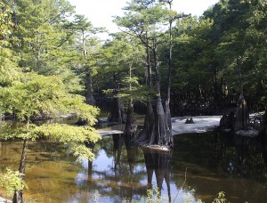
From the cool, clear water of Morrison Springs in the northeast end of the county, to Lost Lake near Bruce, there is a wide variety of flora and fauna can be experienced in the many parks Walton County has to offer.
Many of the parks have playgrounds and sports facilities, along with walking trails, swimming holes and boat ramps.
To reserve use of a park pavilion or building, click here for rates and rental application or contact Walton County Parks and Recreation at 850-892-8108, Mon – Thurs. 6 a.m. – 4:30 p.m.
So, pack a lunch, or put on your hiking boots, here is a list of a great 28 that are right here in Walton County:
North Walton:
Lake Jackson – DeFuniak Springs
From U.S. Highway 90 in DeFuniak Springs go north on U.S. Highway 331 for 18 miles. Turn left onto Lake Road and follow until park comes into view. This park has no facilities, only a boat ramp. ::Map::
• Boat ramp
Lakewood Park – Florida’s Highest Point – Paxton area
Take U.S. Highway 331 north through DeFuniak Springs. Once past DeFuniak, go 18 miles and turn right on County Road 285. Park will be on left side of road.• Picnic area, restrooms, trail, and scenic views. ::Map::

Cat Island– DeFuniak Springs
Take U.S. Highway 331 north through DeFuniak Springs to U.S. Highway 90 and turn right. Turn left on N. 9th Street (SR 83) and travel 3.3 miles. Turn left onto Cat Island Road. Follow this road to its end, approximately 1 mile.
• Picnic area, restrooms, boat ramp
Juniper Lake– DeFuniak Springs
Take U.S. Highway 331 north through DeFuniak Springs to U.S. Highway 90 and turn right. Turn left on N. 9th Street (SR 83) and travel 2.6 miles. Turn left onto Juniper Lake Road, traveling for approximately 0.8 miles. The county lands sit along both sides of the earthen dam. • Picnic area, restrooms, boat ramp  ::Map::
Wee Care Playground– DeFuniak Springs
Take U.S. Highway 331 north through DeFuniak Springs to U.S. Highway 90 and turn right. Turn left on N. 9th Street (SR 83) and travel 1.5 miles. Turn left onto Walton Road and proceed for approximately 0.4 miles. The children’s park is located on the right, across from Walton High School. • Playground, restrooms, picnic area.
Recreation Complex– DeFuniak Springs
Located at 965 Gene Hurley Road, west of DeFuniak Springs, off of U.S. Highway 90, just west of U.S. Hwy. 331. Turn south on Gene Hurley Road, around the landing pad of airport, park is on the left.
• Playground, picnic area, restrooms, ball fields, skating and rollerblading ramps, nature trail.

Chipley Park (Lake DeFuniak)– DeFuniak Springs
Located in downtown DeFuniak Springs on Circle Drive. • Playground, boat ramp, restrooms. ::Map::
Douglass Crossroad Ball Park– DeFuniak Springs
Head east on U.S. Highway 90 in DeFuniak Springs for 4.1 miles. Turn right on CR183S for 2.8 miles. Immediately after crossing over I-10, turn left on Douglass Crossroad and go approximately 1.5 miles. The park is on the right.
• Playground, restrooms, ball fields ::Map::
Berrian Lake – Ponce De Leon area
From the Walton County Courthouse, Berrian Lake can be accessed most easily by following U.S. Highway 90 into Holmes County and reentering Walton County from CR 181A. Head east on U.S. 90 for 10.5 miles. Turn right onto CR 181A and go for 1.1 miles until reaching Old Mt. Zion Road. Turn left and follow for 2.1 miles until road forks. Follow the right fork for 1.9 miles to CR 181. Bear left and go for 0.6 miles, then turn onto Berrian Lake Road. Continue on this road, following the signs to the landing.
• Boat ramp
Cedar Log – Red Bay area
Take U.S. Highway 331 north to State Road 20 in Freeport. Turn right and go to State Road 81. Turn left and go right on CR 181 for 2.1 miles then right on Cedar Log Road (dirt) for 1.3 miles to ramp.
• Boat ramp
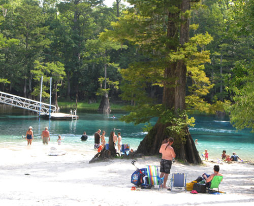
 Morrison Springs – North of Red Bay
Take U.S. Highway 331 north to State Road 20 in Freeport. Turn right and go to State Road 81. Turn left and go past Red Bay to County Road 181C. Turn right and continue for 1.6 miles. Then, turn right onto Morrison Springs Road and follow to its end.
• Picnic area, restrooms, swimming, diving, boat ramp ::Map::
Click here for story and video on Morrison Springs
Comander’s Landing – North of Red Bay
Take U.S. Highway 331 north to State Road 20 in Freeport. Turn right and go to State Road 81. Turn left and go past Red Bay to River Road, proceed to the end of the road.
• Picnic area, boat ramp ::Map::

Bruce Creek Park – Bruce
Take U.S. Highway 331 north to State Road 20 in Freeport. Turn right and go to State Road 81. Turn left and go past Red Bay to Camp House Landing/Louis Miller Road and turn right.
• Hiking trail, boat ramp ::Map::
 Dead River Park – Bruce
Take U.S. Highway 331 north to State Road 20 in Freeport. Turn right and go to State Road 81 follow Dead River Road. Turn left beside the Dead River Cemetery and follow the road to the end.
• Picnic area, boat ramp, playground, portable toilet, primitive camping managed by Northwest Florida Water Management
::Map::
Seven Runs Park – Bruce

Take U.S. Highway 331 north to State Road 20 in Freeport. Turn right and go to State Road 81. The park is on the left (west) side of the road at the foot of the Seven Runs Creek Bridge. The newly opened Florida Trail at Nokuse is just south of Seven Runs Park.
• Picnic area, Boat ramp, Portable toilet ::Map::

Tilley Landing/Lost Lake – Between Bruce and Red Bay
Take U.S. Highway 331 north to State Road 20 in Freeport. Turn right and go to State Road 81. Turn left and take State Road 81 until you see the sign on right.
• Primitive camping, portable toilet, boat ramp, picnic area. Click here for camping reservations.
For more information on Lost Lake Click here for story on Lost Lake at Tilley Landing
H. A. Laird Park – Freeport

Located on SR 20 West about 1.5 miles west of the intersection of U.S. Highway 331 and State Road 20 West.
• Playground, picnic pavilions, restrooms, short trail
::Map::
Alaqua Creek Park – Freeport
From Freeport: Head west on SR 20 for approximately 2 miles. Park is on the north side of State Road 20.
• Picnic area, boat ramp, restroom, swimming, portable toilet ::Map::

Alaqua Park – Freeport
From Freeport, head west on SR 20 for approximately 3.6 miles. Turn left onto Portland Park Road. Follow this clay road to its end.
• Picnic area, boat ramp ::Map::
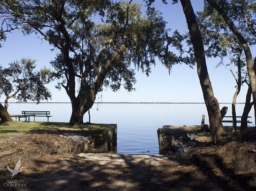
Choctaw Beach Park – West of Freeport
More than a boat ramp, the Choctaw Beach Park offers spectacular sunsets and many public amenities on the north side of the Choctawhatchee Bay. From Freeport, head west on SR 20 for approximately 12 miles. The park is on the left, fronting the bay. • Picnic area, restrooms, pavilion, playground ::Map::
Freeport pool
Managed by the city of Freeport
Located behind Freeport City Hall on SR 20 in Freeport.
• Open Memorial Day – Labor Day. For more information call (850) 835-1223 ::Map::
Casey Kids Park – Freeport
Casey Kid’s Park is a small playground located next to city hall on State Road 20 in Freeport
• Playground, picnic area ::Map::
 Freeport Regional Sports Complex
Freeport Regional Sports Complex is located off State Road 20 in Freeport, on CR 83A.
Baseball/softball fields, football/soccer fields, tennis courts, sand volleyball court, basketball courts, shuffleboard courts, playground, barbecue/picnic areas, playground, restroom, walking trail and disk golf course. ::Map::
Marse Landing – Freeport
Know by the locals as The Point, Marse Landing now boasts more than 20 parking spaces and several boat slips. In addition, there are restroom facilities and walkways that wrap around the waterfront. 336 Shipyard Road, Freeport, FL 32439
Directions:
Take State Road 20 and turn south on CR83A across from City Hall. Turn left on Four Mile Road (Shipyard Road). Follow the road past Freeport Shipyard. The park is at the end on “The Point.” ::Map::
Grady Brown Park – Freeport
Grady Brown Park offers a number of amenities that greatly improve the recreational opportunities in the area, including an abundance of green space to throw down a blanket, and relax under an oak tree. The park features a sandy beach, boat ramps, handicapped accessible kayak launch, picnic tables, grills, restrooms.
Park is located at the northwest end of the Clyde B. Wells causeway at the corner of Bay Grove Road and U.S. Hwy. 331. The address is 20940 US Highway 331 South, Freeport. ::MAP::
South Walton:
Thomas Pilcher Park along the Clyde B. Wells Bridge
The Thomas Pilcher Park along the Clyde B. Wells Bridge (U.S. Hwy. 331) is now open. Amenities of the park include:
• 380 ft. fishing pier
• Four boat ramps
• Five 55 ft. docks along the boat ramps
• Two 24’ x 24’ picnic shelters
• Restrooms
• Fishing platforms
• Scenic overlooks
• Western scenic walkway/bike path
• Parking for 21 boat trailers and 69 spaces for other vehicles
• ADA access
To access the park from the south, stay in the right lane as you approach the bridge. The access road is on the right and continues underneath the bridge. Coming from the north, stay in the left lane. At Chat Holley Road, make a U-turn. Caution, as this may present a challenge for larger trailers.
The exit from the park accesses southbound traffic. The official address is 21987 U.S. Hwy. 331, Santa Rosa Beach. The park is open 24 hours a day.
Creek Trail offers four miles of meandering trails around South Walton’s Government Center a pleasant walk or bike ride
Many folks aren’t aware of the scenic, leisurely trails located around the busy South Walton Government Annex buildings in Santa Rosa Beach. The trails offer more than four miles of hiking and biking enjoyment. Easily accessible, one can meander along and enjoy the beauty of South Walton’s natural resources.
 The trails boasts forest footpaths, multi-use paved trails, and bridges crossing over wetlands areas. A variety of trees such as sand pine, scrub oak, magnolia, titi, pond cypress and wax myrtle provide a shaded canopy throughout a portion of the trail system, and is a great location for birding.
Most of the trails are located around the northwest corner of U.S. Hwy. 98 and U.S. Hwy. 331. The trails can be accessed at a variety of locations. ::TRAIL MAP::
Another interpretive trail not shown on the map meanders around Northwest Florida State College adjacent to the Government Center.
The Native Plant Demonstration Garden and Trail is a joint project of the Walton County Master Gardeners, Northwest Florida State College, and the Choctawhatchee Basin Alliance. This trail was developed to familiarize residents, visitors, and students with some of the most common native trees, shrubs and wildflowers that thrive in this small ecosystem in South Walton County.
The multi-modal trail wraps around the south-and-western edge of the college’s South Walton Center property. There are interpretive markers along the trail which provide educational information on various plant species. Click here to download accompanying TRAIL GUIDE.
The garden demonstrates best practices for the use of native plants, water conservation, and other Florida-friendly gardening techniques for the home landscape.
The easily navigated trail was well planned out and offers something for most every nature lover. The area boasts creative sculptures and painting by local artisans, a meditation area, seating, and is also ADA accessible.
For more information, contact the NWFSC South Walton Center at (850) 200-4160. South Walton Center of NWF State College is located at 109 Greenway Trail, Santa Rosa Beach. ::MAP::
Cessna Landing at Hogtown Bayou – Santa Rosa Beach
Take County Road 393 north from U.S. Highway 98 approximately 3 miles. Cessna Landing is on the left.
• Picnic areas, restrooms, playground with ball courts, boat ramp
::Map::
Helen McCall Park– Santa Rosa Beach
Helen McCall Park is off U.S. Highway 98 in Santa Rosa Beach west of County Road 393. Turn south onto Moll Drive and follow to the park.
• Playground, ball fields, restrooms ::Map::
Legion Park – Miramar Beach
Legion Park is located in Miramar Beach approximately 1 mile west of Sandestin off U.S. Highway 98. Going west turn left on Ponce deLeon Drive. Park is located at the end of the street.
• Playground, picnic area, restrooms, basketball court, shuffleboard court, boat ramp
::Map::
Fishing Pier on Lake Powell – Inlet Beach area
The fishing pier is located at the eastern end of South Walton County of U.S. Hwy. 98 on Lake Shore Drive off of Orange Street, north of Inlet Beach. It is is approximately 50 feet in length with a 10×15 ft. deck at the end with a bench overlooking the lake. ::Map::
Padgett Park – Santa Rosa Beach behind South Walton Annex
 The park is named after Timothy Padgett, a Special Forces medical sergeant from Walton County who died in the line of duty in Afghanistan in 2007.
The park boasts picnic areas, a splash pad, and a community center. The center was designed as a multi-use facility with a kitchenette. It can be used for meetings or set up as a classroom environment. To reserve use of the park, click here for rates and rental application or contact Walton County Parks and Recreation at 850-892-8108, Mon – Thurs. 6 a.m. – 4:30 p.m.
::Map::
Kellogg Bayfront Park – Santa Rosa Beach
 Kellogg Bayfront Park in Santa Rosa Beach boasts panoramic vistas, along with easy access to the bay for kayaks, canoes, and stand up paddle boards. Amenities include vessel ramp, several picnic tables, shower, water fountain and water spigot.
The fenced park area does not include vehicle parking, however you may facilitate the ramp area while unloading vessels. Parking is available just outside the fenced area. Boat access is not offered at the ramp.
The park is located at the north end of Nellie Drive off of Nursery Road. ::MAP::